![]()
Scorch
Problem
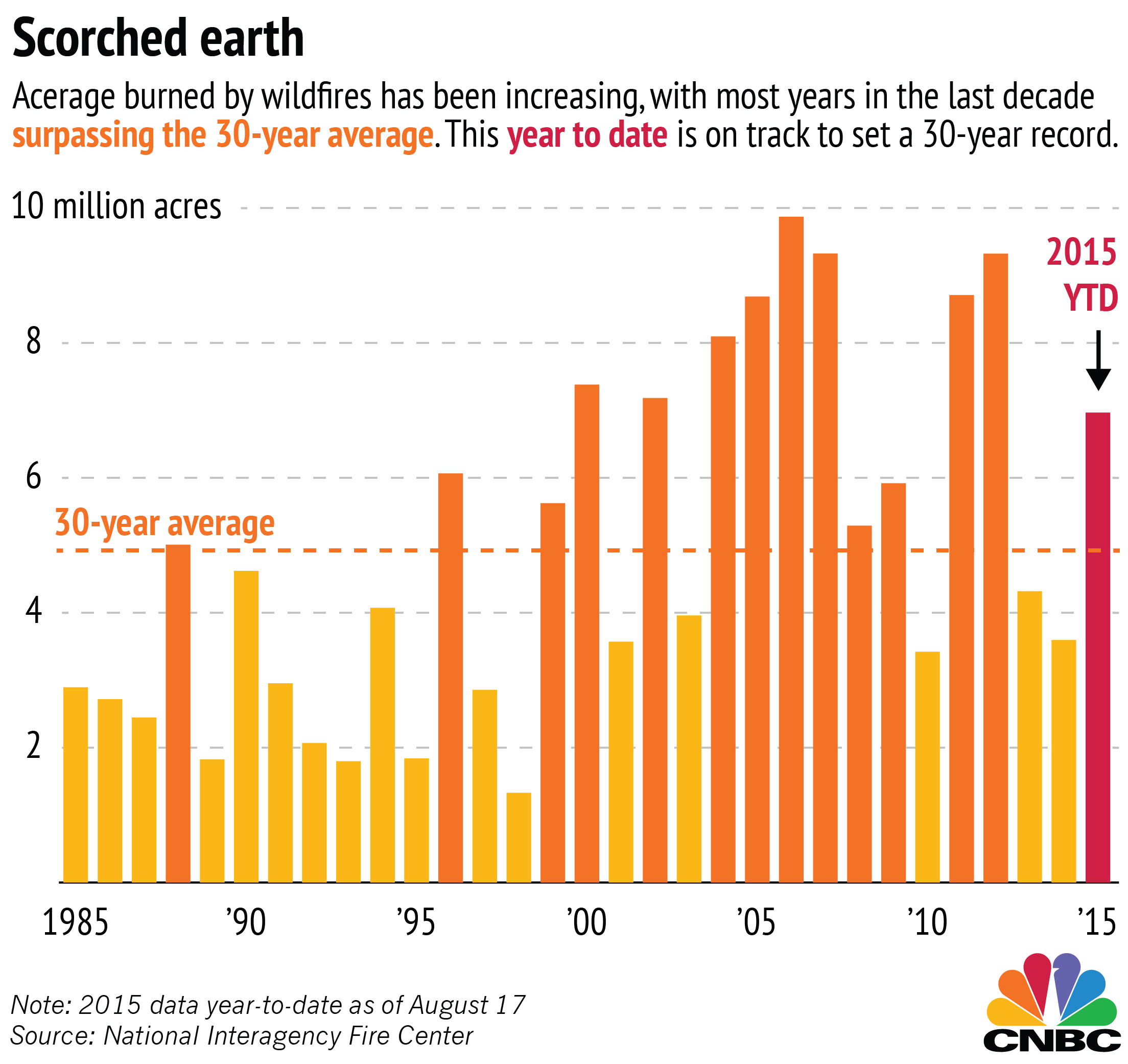
Wildfires are getting worse each year. Acreage burned by wildfires and the number of wildfires burning more that 50,000 acres has continued to increase over the last 30 years.
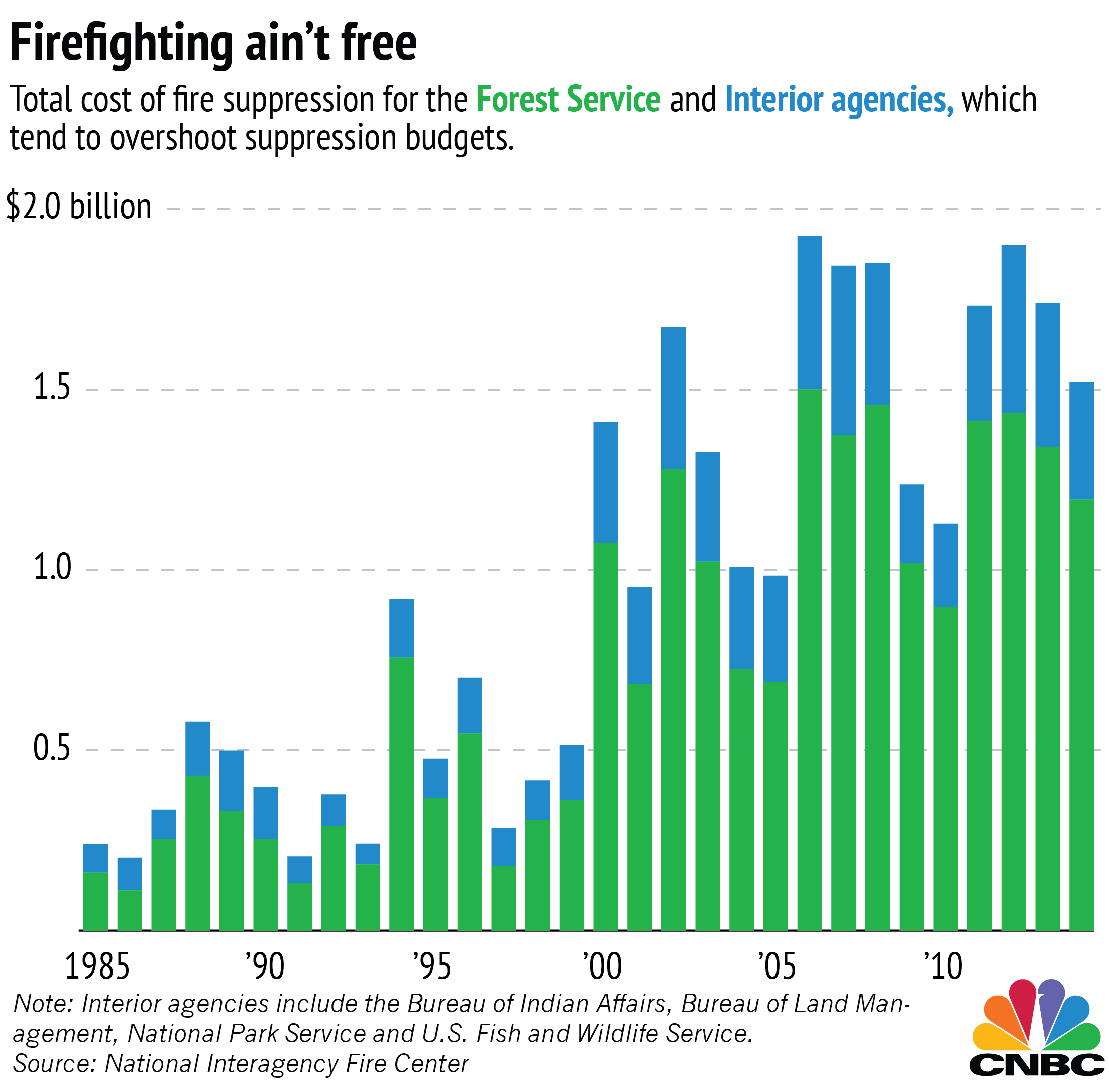
Beyond the sheer devastation, forest fires are also a massive expense to the US government. Suppressing the fire requires hand crews, tankers, chemicals, and helicopters, not to mention firefighters. The fire management budget in the US is already up by 60% from a decade ago. More and more frequently, the Forest Service spends close to $2 billion per year on fighting fires.
Fire seasons have grown much longer, both in the US and across the globe. Earlier this year, more than 90 blazes scored 180,000 hectares, razed hundreds of homes, destroyed villages, cattle, and crops in Chile. As climate change continues to take hold, we will see more droughts and bigger and more severe fires will cause greater destruction of people’s lives and the economy of entire regions. CoreLogic estimates that US homes in the high or very high risk for wildfires could cost up to $237 billion to rebuild.
Opportunity
In the last decades, wildfire fighting has evolved by taking into account a more data driven approach to fighting, detecting and predicting these types of incidents. The first data driven models focused primarily on the study of weather. As the weather can determine how dangerous the fire can become, specialists started to analyze weather conditions during wildfires to fight them back.
Subsequently, other data were aggregated to build models for fire-behavior analysis to predict how flames will spread. Most of these models were reinforced with other data like the topography and fuel conditions, as well as smoke distribution forecasts. The problem of these approaches is that they look to mitigate the problem rather than prevented.
Then, the era of satellite imagery came and since then, satellite imagery has been used to try to detect forest fires. The problem is that it can not be used in real-time for fire prevention due to the amount of time needed to gather the data. In the same way, data from this type contain a high number of false positives for fires, ranging from hot asphalt parking lots to house fires to farmer burn piles.
What if we could use weather forecasting, topological data and real-time drone imagery to aid in forest fire protection?
Solution
Scorch will solve the wildfire problem with a technology that scouts fires before they flare up so firefighters can stop the flames early on. Evidence from Gamaya, a crop scouting company, and satellite imagery from NASA show that data science could effectively identify and detect fires. Scorch will use drones to fly over areas at high risk of wildfires and capture information through our hyperspectral camera (measures the light reflected Plants reflected by plants; reflection patterns change according to different stages in the life cycle and conditions of the plants). The image data will be processed through our algorithms that will be trained through crowdsourcing/ human intelligence tasks on Amazon Mechanical Turk and verified by fire experts. The results will be immediately sent out to the nearest fire station with recommendations to the firefighters and updates as the fire progresses. As we collect more data, we will use machine learning algorithms to increase accuracy even further.

Concerns
One of the concerns is the frequency of false positives. Prior imaging software could falsely detect wildfires that are actually farmer burn piles or hot asphalt parking lots. This could lead to falsely deploying units that could actually cost more money. The Scorch algorithm would use historical fire perimeter boundaries and weather data to hone in on actual wildfires.
Another concern is the U.S. regulatory environment regarding drone use that might difficult initial testings. This could be solved by implementing the pilot program outside the U.S., notwithstanding this changes in international drone regulation might affect our ability to expand to relevant regions. This problem can be mitigated by working with authorities due to the public interest surrounding the problem that we are trying to solve.
Next steps and ask
In order to build this product, we need to hire developers and to set up crowdsourcing to train our imagery algorithm to properly focus in on wildfires. Additionally, we will do some testing to determine how much a drone could cover in order to be efficiently capture images useful for our purposes. In order to do this and develop our MVP, we are looking for a seed round of $150,000.
Sources
- http://www.cnbc.com/2015/08/19/what-the-wildfires-are-costing-us.html
- https://www.theguardian.com/world/2017/jan/25/chile-fire-firefighting-international-help
- http://blog.galvanize.com/fighting-forest-fires-with-data-science/
- http://www.popsci.com/year-wildfire#page-4
- https://github.com/sallamander/forest-fires
- https://www.ncbi.nlm.nih.gov/pubmed/12148070
- http://lias.cis.rit.edu/projects/wasp
- http://gamaya.com/