In the event of natural disasters, aid delivery and disease prevention are inefficiently delivered due to lack of information. We use drone imagery and predictive analytics to plan aid delivery efforts and prevent outbreaks following natural disasters
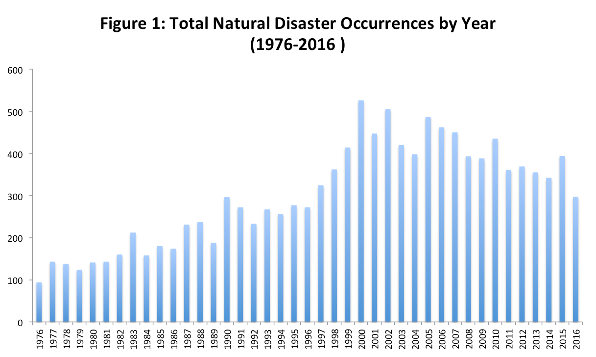
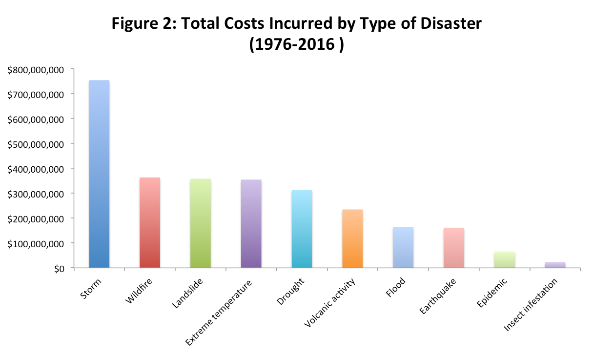
In 2015, there were 376 natural disasters that registered resulting in $70.3B in damages, which is actually below the 10-year trailing average of ~$160B.[1] In addition, these disasters can result in slowed economic growth due to loss of infrastructure, productivity decreases, labor supply losses etc. bringing total average yearly cost to ~$250-$300B[2]. While the overall number of disasters has been trending up, flooding is the most common natural disaster over the last 20 years accounting for ~45% of total natural disasters recorded. On the other hand, storms tend to have the costliest immediate impact (See Figures 1 & 2)[3].
Despite these enormous costs, the distribution of aid is relatively inefficient to this day, which causes more costs to be incurred than is needed. For example, during the earthquake in Haiti back in 2010 even though there were over 900 NGOs on top of the UN, military, and other organizations who came in to help, aid distribution was severely delayed due to communication gaps, logistical issues with the collapse of infrastructure, and overall coordination[4]. In addition, disaster relief spans not only the initial rescue, medical, food, water, and shelter assistance but also longer term infrastructure rebuilding and potential disease and outbreak mitigation efforts due to population displacement and unsanitary conditions. In the US, we find that the federal government ends up shelling out the majority of funds with states and other organizations following suit, so there is definitely demand for cost reduction.
Modern communication technology has helped in requesting for assistance and mobilizing relief in a matter of hours. However, the task of humanitarian logistics[5] lies with the authorities on the ground which include relief organizations, local governments and emergency services. Humanitarian logistics prioritizes quick response and demand satisfaction over profit as being important parameters while delivering relief. In other words, the right goods should reach the right place, at the right time (within the shortest possible time) to those who need it the most. While disaster preparedness remains a top priority for governments and technology has been incorporated in aid mobilization, research[6] indicates that limited assess visibility and procurement could have helped minimize the impact of Katrina.
Given this assessment, we see two key need areas where we believe that technological advances could be valuable. The first is optimizing aid delivery efforts by generating satellite images of the landscape of an area hit with a natural disaster instead of solely relying on volunteers on the ground to classify damages and other potential risks such as people who are trapped and standing water that could lead to infestation and disease as well as the distribution of the population and water sources to allocate food and water effectively. By acquiring this knowledge quickly and without significant additional human effort, we believe that the government and organizations could more efficiently diagnose how and where to allocate efforts from the get-go. The second need area we identified relates to the long-term costs of post-disaster disease outbreaks. We believe the data generated from the satellite imagery captured during initial relief efforts can also be used as inputs to predict the likelihood of disease outbreaks such as malaria and dengue.
Our product Aerial Intelligence Response uses surveillance data and machine learning to assist with effective disaster response plans and minimize disease outbreaks.
- CAPTURE accurate view of the disaster region through drones
- This allows agencies to ASSESS immediate impact of disaster. For instance, damaged infrastructure and areas prone to flooding can be instantly identified using machine learning algorithms that compare against
- DEPLOY aid and evacuation capabilities based on need and extent of damage.
Using machine learning to improve humanitarian logistics
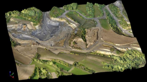
After a disaster, response teams are short on critical information related to infrastructure, health, and safety. The first stage in our response plan is to use drone technology to create an accurate map of the affected areas. Commercial drone systems outfitted with image, infrared, and LIDAR sensors are deployed in order to collect data. A single drone is able to survey approximately 3 acres of space per minute, meaning a fleet of 100 drones would be able to scan an area approximately the size of the city of Chicago in just 8 hours[7]. Open source flight planning and autopilot technology allows for the simultaneous deployment and monitoring of the drones at an extremely low cost[8].

Following this survey, the data collected by the drones is uploaded to a cloud-based storage system, and processed into an orthorectified, multi-layered map. This process takes place using several computer vision algorithms such as keypoint detection for image stitching[9], and Structure from motion (SfM)[10] for creating three-dimensional maps from two-dimensional images. The map data can be viewed in a browser-based tool in order to assess the situation or annotate the images with additional metadata.
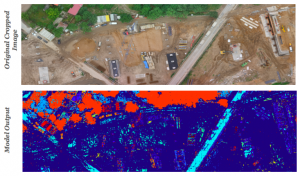
Once a complete survey of the affected area has been generated, machine learning algorithms are used to automatically identify key points of interest in the data such as infrastructure damage and equipment. This helps responders plan for and optimize the distribution of aid. These algorithms can also classify natural features of the landscape such as homes, vegetation, and areas of flooding. These data are then used as inputs to forecasting models for predicting future disease outbreaks.
From a technical standpoint, the machine learning algorithms used to automatically classify the drone survey data are a class of deep learning models called convolutional neural nets (CNNs). These CNNs are networks that take in image data as input and generate a pixel-wise classification of the content of the image. Our approach uses two specific, open source[11] network architectures in order to detect objects and classify the scene. The first model, used for finding objects such as equipment, vehicles, or infrastructure, is called Faster RCNN[12]. The second architecture, called fully convolutional semantic segmentation networks[13], allow us to take the image and infrared data returned by the drone and generate a map layer displaying where different features of the landscape are located.
After drone data has been captured and analyzed, it is fed into a database which includes data on conditions which may impact the spread of communicable diseases. Examples include number of inches of rainfall, humidity conditions, and the temperature range by latitude and longitude of the surveyed area. A machine learning algorithm trained on historical data is then used to forecast the probability of the disease spreading through the region. Based on this, the software can populate a heatmap with probabilities and compare to actual infected areas. This information is critical for groups considering the optimal distribution of resources[14].
Measuring success
AIR will be deployed to state and national governments, WHO, Salvation Army, FEMA, EPA, and American Red Cross, among others, to direct aid efforts better and prevent illnesses from becoming outbreaks by isolating infected areas. AIR’s success will be measured by the improvement in on-the-ground personnel response time, reduction in physical supply waste, reduction in post-event hospitalization rates and time saved in reaching target locations.
The effectiveness of this technology relies on disaster response agencies’ abilities to be tech savvy and willing to learn the technology. Initial database needs to be populated with open source learning libraries and network architectures must be tested to ensure they will be sufficient for timely processing and analysis of the aerial surveys. Government agencies’ openness to change and willingness to steer away from current procedures will also be critical to AIR’s adoption and success.
Funding Ask [Update]
We request $200,000 of funding in order to test and build the survey-classify-annotate model and build partnerships with potential client organizations.
This will enable our venture to fund:
-
- Contract UAV aircraft and pilots
- Cloud server space
- Commercially available software
- Travel expense
References
[1] http://reliefweb.int/report/world/annual-disaster-statistical-review-2015-numbers-and-trends
[2] https://www.forbes.com/sites/marshallshepherd/2016/05/12/weather-caused-90-of-natural-disasters-over-the-past-20-years-and-impacted-the-global-economy/#6c749862671d
[3] http://www.emdat.be/
[4] http://insidedisaster.com/haiti/response/relief-challenges
[5] http://ac.els-cdn.com/S1877705814035395/1-s2.0-S1877705814035395-main.pdf?_tid=e4a518c0-329f-11e7-857a 00000aacb360&acdnat=1494104977_e7dfa68e900fa0e247d652699d678027
[6] http://transp.rpi.edu/~HUM-LOG/Doc/Vault/katrina1.PDF
[7] http://cmemgmt.com/surveying-drone/
[8] https://pixhawk.org/modules/pixhawk
[9] https://en.wikipedia.org/wiki/Image_stitching
[10] https://en.wikipedia.org/wiki/Structure_from_motion
[11] https://github.com/rbgirshick/py-faster-rcnn
[12] https://arxiv.org/pdf/1506.01497.pdf
[13] https://people.eecs.berkeley.edu/~jonlong/long_shelhamer_fcn.pdf)
[14] https://wwwnc.cdc.gov/eid/article/13/1/06-0779_article