Feb 28, 2020 |
Christian Rocha, Doctoral Candidate, History

Figure 1. The inner courtyard of the Archivo Historico Municipal de Tijuana (AHMT), former site of Tijuana’s municipal government.
To visit the Archivo Histórico Municipal de Tijuana (AHMT) is to experience the sensory overload typical of urban life. The building itself is an uneventful structure painted in pale brown, a color devoid of any obvious political party associations. The surroundings of the complex, however, teem with life. The archive is located in the midst of the old centro, uncomfortably close to the epicenter of the city’s red-light district. The AHMT shares the intersection of Calle Segunda and Avenida Constitución with a 7-Eleven, a supermarket that has a name with regionalist undertones, and a pharmacy that displays ads in English. The border wall dividing Tijuana from San Diego is less than a kilometer away. Plastic papel picado in the Mexican flag’s colors hangs by a nearby McDonald’s, the obligatory reminder that one is still in Mexico. Even the mere act of walking into the archive’s building triggers the senses. One has to navigate the throngs of pedestrians marching along busy Calle Segunda, hear the noise of traffic rushing away from downtown, and even smell the invariably nauseating stench emanating from the trash can at the corner of the block. A more adventurous researcher may even decide to savor the taste of the city during lunch by eating a shrimp taco at a neighboring “hole in the wall.”
As a historian of Tijuana’s urbanization, I am particularly concerned with depicting the texture of city life in my account of the boomtown’s history between 1955 and 1993. Yet, how can a historian access the sensorial experiences of the past? How can we bring the smells, colors, or sounds of 1950s Tijuana back to life without ever having been there?
The interior of the bland AHMT building holds the key to tapping into the historical sensory experience of the period: the permisos de ambulantes. These documents are the result of a bureaucratization of street life that started as early as 1955. The typical application contained information about the ambulante’s place of residence, the goods he or she wanted to sell, and the area of town where the person would work. Some of the folders also include relevant documents regarding potential organizational memberships or letters of recommendation supporting the applicant. Most of the permisos also contain a picture of the vendor. One can even verify an applicant’s literacy status by checking whether he or she was able to provide a signature. The permits, and the paperwork necessary to obtain them, then, are a singular window into street life during the period between 1955 and 1982.
Figure 2. The inner courtyard of the Archivo Historico Municipal de Tijuana (AHMT), former site of Tijuana’s municipal government.
A sensory portrayal of Tijuana’s centro can be reconstructed in part from the information in the permisos de ambulantes. The documents suggest a vendor’s contribution to the city’s cacophony, odors, or visuals. Three elements have to be considered. First, the specific itinerant has to be identified and associated with a given space that can be described and analyzed. It is difficult to account for a vendor’s contribution to the overall urban atmosphere otherwise. A second step is to appraise the sensory output of the items or services sold by the vendors according to the permit. Distinct goods contributed to the area’s smell in different ways. The stench of shoe polish, for instance, was not the same as the aroma of fresh fruit. Similarly, a trinket was more likely to make clanking noises than a bag full of cigarette boxes. The third element is to consider the mere impact that the vendor had by performing his or her role at a given site. A taquero by a row of bars was likely to attract clients. The sounds of drunk customers ordering tacos contributed to downtown’s cacophony even as the rest of the city slept.
The files of just three street vendors help us recreate the atmosphere of the blocks near the AHMT building during 1958. At the time, the complex served as Tijuana’s municipal seat of government. Ramón Arroyo was a constant presence at the corner of Calle Primera and Avenida Revolución. He stood at the invisible boundary between the respectable side of downtown and the edge of the red-light district. A blind cigarette salesman, his voice should have served as a warning to the respectable tourist that he was approaching the lurid underbelly of the city.[1] The next block over, closer to Tijuana’s seedy district, Javier Loza Bustamante sold tacos and other comestibles.[2] The third itinerant worked just one street north from the AHMT building. Alejo González was a shoeshine on Calle Primera and Avenida Constitución.[3] It is conceivable to imagine how a municipal employee may have walked down Avenida Constitución for a quick lunch at Loza Bustamante’s stand just two blocks away. The bureaucrat could have passed by González’s chair, possibly overhearing him talk with a customer or smelling the shoe polish, before crossing Calle Primera. At this point, the employee may have been able to overhear Ramón Arroyo as the cigarette salesman walked his predetermined route centered around the intersection of Calle Primera and Avenida Revolución. It was only a few steps to the bureaucrat’s lunch destination after this. The alluring smell of grease and meat would have welcomed the hungry employee. We have no record of the quality of Loza Bustamante’s food. Yet, his relatively short stint as a documented downtown taquero suggests that the taste of the tacos may have been not the best in town.
We get another glimpse of the area’s density of street commerce from the complaint of an itinerant candy saleswoman. María del Refugio Pérez worked at Parque Teniente Guerrero, located five blocks away from the current AHMT building. Frustrated with the high density of ambulantes in the area, she requested the municipality to change her zone of operations in March of that year. She asked the authorities if she could instead work one block away from Alejo González’s shoe shinning operation.[4] It was a fruitless effort. The authorities promptly rejected her appeal claiming that Calle Segunda was already overwhelmed with itinerant salesmen.[5] Then, our hypothetical bureaucrat would have encountered many more ambulantes on his way to lunch at Loza Bustamante’s taco stand. Each one of these vendors could have further contributed to the overall sensory overload of the centro.
Ultimately, the permisos de ambulantes are just one of the different tools available to feel 1950s Tijuana. They bring together the lives of Tijuanenses otherwise absent from the historical record, the quotidian experiences of the old centro, and the sounds, smells, and sights of a past living city.
[1] AHMT, PM 411.5/2426
[2] AHMT, PM 411.5/2657
[3] AHMT, PM 411.5/3051
[4] AHMT, PM 411.5/2451, “Tijuana, B.Cfa a 19 de marzo de 1959”
[5] AHMT, PM 411.5/2451, “2622 a 20 de marzo de 1959”

Figure 3. The permiso de ambulante for María del Refugio Pérez for 1958-1959. AHMT, PM 411.5/2451
Jan 9, 2019 |
Jack Mensik, MA Student, LACS
“This is the water!” Elena exclaimed. She scurried back to the living room from the kitchen and excitedly set the glass down on the table in front of me.
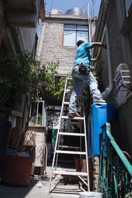
“Wow, it looks pretty clean,” I responded. I was not exaggerating. Specks of distant sunlight shimmered in the translucent water, whose unblemished appearance belied the fact that it had been collected from rainfall in a city notorious for its air pollution. For the past few years, Elena and her husband, Antonio, have relied on a household rainwater harvesting system to meet a substantial portion of their family’s water needs. Isla Urbana, an organization dedicated to the proliferation of rainwater harvesting in Mexico City, designed and installed this system, which captures water from Elena and Antonio’s roof, passes it through a series of filters, and stores it in a 5000-liter plastic cistern in their backyard. In their kitchen, another set of filters purifies the water to a quality suitable for drinking. They’ve done tests, Elena told me, and the quality is consistently excellent.

Figure 1. A household rainwater harvesting system that serves as an important source of clean water for residents of Mexico City’s periphery.
In truth, the clean water contained in the glass offers Elena and Antonio more than just good health. It affords them the possibility for a stable livelihood amidst circumstances in which they enjoy only marginal access to the rights and privileges promised to citizens of North America’s largest city. Reliance on the rain has meant that the family is no longer at the mercy of a government that is unsure of whether their household is deserving of piped water service. Yet, as Elena beamed with pride over the immaculate glass, I also wondered whether this newfound stability would make their otherwise rightless status more tolerable. After all, why would the family bother to seek legal recognition from government authorities if a public service like water was no longer urgently needed?
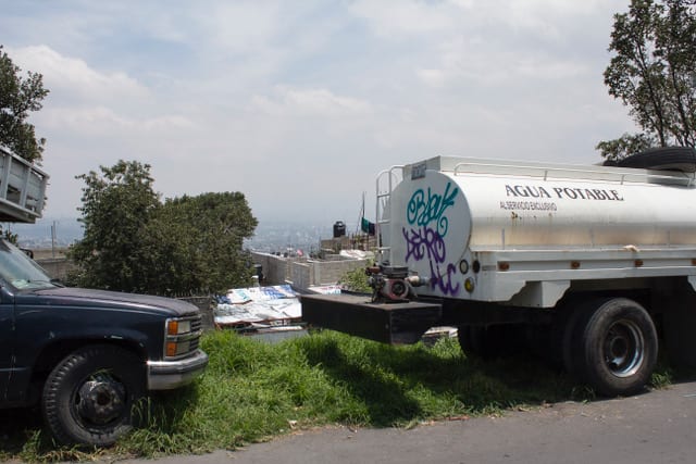
Elena and Antonio’s lack of formal land tenure explains how they discovered rainwater harvesting, and why they are so enthusiastic about it. The family’s home sits in a rolling mountain valley on the southern periphery of Mexico City within the city’s “ecological zone”, a conservation area in which human habitation is prohibited. Elena, Antonio, and their young children settled the unoccupied piece of land without legal sanction in the early 2010s. The growing family had become too big for their small house in San Gregorio Atlapulco, an urbanized area located a few miles away in the borough of Xochimilco. They had to build a home from scratch on the mountainside, but they found relief from the cramped conditions in which they had been living. Yet, because they had illegally occupied their land, they were ineligible for almost all government services. Elena and Antonio felt the absence of piped water most acutely. They narrowly missed an opportunity to enroll in a municipal program that would have offered them a monthly delivery from water trucks (locally known as pipas) at a subsidized cost. Meanwhile, the full cost of a monthly pipa delivery was more than they could afford on a regular basis. So, they would make trips down to a pump in San Gregorio, fill up a half-dozen or so 19-liter jugs with water, and either hire a taxi to bring them home or haul the jugs back uphill themselves in a cart. It was tiresome work, but unless the city government redesignated their community’s land tenure status as part of the “urban zone”, rather than the “ecological zone”, avenues for improvement remained limited.
Figure 2. An example of a pipa, or water tanker truck, that delivers water to many of Mexico City’s residents.
Elena and Antonio’s decision to seek a better life on Mexico City’s geographic and legal periphery repeats a logic that has been commonplace in the city for nearly a century. Since the end of the Mexican Revolution in 1917, inner-city residents have looked to the city’s periphery as a place where single-family home ownership could be realized, far from predatory landlords, burdensome rents, and squalid living conditions. Meanwhile, since the end of the Second World War, informal settlements on the periphery have also absorbed influxes of rural migrants seeking economic opportunities in the national capital. Over time, many informal communities have received legal recognition from the state, and have been integrated into the city through the extension of public services. These patterns of migration, settlement, and eventual legalization have played a key role in the Mexico City’s rapid expansion from a contained city of 369,000 in 1900 to a sprawling megalopolis of over 20 million today.[1]
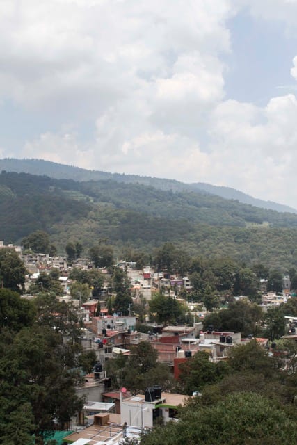
Yet, city and municipal governments are often hesitant to recognize informal settlements. In decades past, officials marshaled concerns about sanitation as a justification. Today, environmental considerations, specifically those surrounding water, occupy a central role in government discourse. The vast majority of the “ecological zone” occupies territory in the southern portion of Mexico City comprised of rural towns, farms, and mountain forest. The area’s vegetation plays a vital role in absorbing rainfall and recharging the subterranean aquifer upon which the metropolis depends for its water supply. Authorities are concerned that unrestricted settlement will lead to urban sprawl and loss of this important green space. [2] These apprehensions are justified, as the future of Mexico City’s water supply looks bleak. Decades of intensive extraction to quench the city’s thirst, coupled with miles of paved surfaces that prevent replenishment, have severely diminished water levels in the aquifer. In fact, this drop has caused parts of Mexico City to physically subside—the sight of uneven streets or buildings tilted at alarming angles are fairly common. Aqueducts that supplement the city with water from neighboring states are inefficient and costly.[3] Indeed, Mexico City is running out of water, and years of unsustainable growth have threatened the city’s survival.
Figure 3. The “ecological zone” found prominently in southern Mexico City in which vegetation plays a vital role in absorbing rainfall and recharging the subterranean aquifer.
However, the city’s vigilance over the aquifer also means that residents living in hundreds of informal settlements within the “ecological zone” are unlikely to receive the adjusted land tenure that will be necessary for basic improvements in water services and infrastructure. “It puts us in a dilemma,” one municipal official told me, “because on one hand, [water] is a right that everyone has. But by beginning to recognize these irregular communities, then what becomes of the conservation of natural land? Yes, [water] is a right, we cannot deny it. But also, there are certain limits that we cannot exceed through our actions.”[4]
Isla Urbana’s rainwater harvesting systems offer one solution to this dilemma, as the contraptions can expand water access without placing additional stress on the aquifer. “Rainwater harvesting gives you a tool that you can select exactly the houses or neighborhoods that are most problematic, or for any reason the city has failed to supply adequately,” explained the organization’s founder, Enrique Lomnitz. If these water stressed areas are supplemented with rainwater, he reasoned, it would reduce the burden on Mexico City’s water supply and infrastructure.[5]
Most of Isla Urbana’s work consists of government-sponsored programs, in which they install rainwater harvesting systems in formally recognized communities where water infrastructure performs poorly. Yet, through private donations, Isla Urbana is also able to service informal communities, many of which are in the “ecological zone.”[6] After connecting with Isla Urbana through mutual acquaintances, Elena and Antonio rounded up enough interested neighbors to begin a project of their own. The couple had to pay 3050 pesos (about $150 US dollars) to cover part of the cost of their own system, but they began harvesting rain shortly after its installation.
So far, Elena and Antonio are thrilled with the results. During Mexico City’s rainy season, roughly between June and October, powerful rains fill their cistern up with water that lasts into the dry season, meaning they save money they spent on pipas and time they spent on trips to the water pump. In the coming years, the couple hopes to expand their storage capacity so that their supply will last even longer. “To this day, we don’t suffer from water,” Antonio declared, “The system is very good and it has helped us a lot.”[7]
While rainwater harvesting has brought greater stability and comfort, the couple still expressed a desire for legal land tenure and improved infrastructure. They would like to see some form of piped water service, or at least more pipa trucks. “We all have rights to these things,” Elena argued, “Just as we have a right to light, we have a right to water. We have rights to urban services. And just because we live up here doesn’t mean we have no rights. We have the same rights as those who live down [in the city].”[8]
I sensed a gap, however, between Elena and Antonio’s belief that they had these rights and their ability to live without them. Previously, I had spoken with numerous residents of formally recognized communities, most of whom saw rainwater harvesting as more of a temporary fix that could never truly substitute for efficient piped water service. Elena and Antonio, on the other hand, seemed committed to rainwater harvesting for the long-term and relatively unfazed by the improbability of infrastructural improvement in their community. When I asked them why, they stated that they were concerned about the dwindling aquifer, and felt that rainwater harvesting and water conservation were essential steps for a better future. Even if their land tenure changed and services arrived, they said, they would continue to harvest rainwater. “We have [rainwater harvesting], it has helped us a ton,” Elena explained, “But yes, if piped water came, then that too. But also…as we said before we have to be conscious, right? Although we have piped water, save it, right? Take care of it.”[9]
Residents of other informal settlements echoed Elena and Antonio’s enthusiasm for rainwater harvesting, as well as their ambivalence toward legal land tenure and improved service. “I am doing very well with rainwater harvesting. I’d neither ask nor demand much else,” one woman told me, “If they come to tell us, ‘Guess what? They’re going to install pipes,’ I’d say, ‘Well, That’s fine. That’s good, isn’t it?’ But if not, then no. Because…with the rainwater harvesting system, well, the truth is that I’m fine.”[10]
Others expressed a similar dedication to rainwater harvesting on account of environmental concerns. “Sure, I would like to see it regularized,” one man said, “but I will keep collecting rainwater. Yes, I would keep doing it. Why? Because this way I am helping out the environment a bit, I’d say. Because sometimes you talk and you don’t do much…”[11]
These comments reveal the extent to which Mexico City’s water crisis is not simply an environmental issue, but cuts to the core of the city’s longstanding struggle with social inequality. Rainwater harvesting appears to do an excellent job of meeting informal residents’ water needs, and provides them with a greater sense of security that they can remain in their homes for the immediate future. Yet, the systems do not resolve critical legal issues surrounding land tenure in informal settlements that would establish permanent residence. Residents’ ambivalence toward resolving these issues may simply reflect doubt that their day of recognition will ever come. Their passion for rainwater harvesting is inspiring, but laden with resignation toward a tolerable, but rightless, livelihood on the periphery.
Both authorities and residents of Mexico City care deeply about their city’s environmental future. However, reaching a sustainable solution to an increasingly dire water crisis will require reckoning with difficult questions about what it means to be a full citizen of Mexico City and who can acquire this status. Until then, every raindrop that falls in the Valley of Mexico will be worth saving.
[1] Matthew Vitz, City on a Lake: Urban Political Ecology and the Growth of Mexico City (Durham, NC: Duke University Press, 2018), 4, 89-92; Thomas Benjamin, “Rebuilding the Nation,” in The Oxford History of Mexico, ed. William H. Beezley and Michael C. Meyer (New York: Oxford University Press, 2010), 470; Wayne Cornelius, Politics and the Migrant Poor in Mexico City (Stanford, CA: Stanford University Press, 1975), 16-17, 27-28.
[2] Jill Wigle, “The ‘Graying’ of ‘Green’ Zones: Spatial Governance and Irregular Settlement in Xochimilco, Mexico City: Irregular Settlement in Xochimilco, Mexico City,” International Journal of Urban and Regional Research 38, no. 2 (March 2014): 573–89, https://doi.org/10.1111/1468-2427.12019.
[3] Barkin, David. 2004. “Mexico City’s Water Crisis.” NACLA Report on the Americas 38, no. 1: 24-28. http://dx.doi.org/10.1080/10714839.2004.11722401; Connolly, Patricia. 1999. “Mexico City: Our Common Future?” Environment and Urbanization 11, no. 1 (April): 53-78. https://doi.org/10.1177/095624789901100116; Kahn, Carrie. “Mexico City Goes Days Without Water During Maintenance Shutdown.” NPR.Org. Accessed November 10, 2018. https://www.npr.org/2018/10/31/662786981/mexico-city-goes-days-without-water-during-maintenance-shutdown.
[4] Interview, August 27, 2018.
[5] Interview, August 14, 2018.
[6] Interview, August 14, 2018.
[7] Interview, August 24, 2018.
[8] Interview, August 24, 2018.
[9] Interview, August 24, 2018.
[10] Interview, August 22, 2018.
[11] Interview, August 15, 2018.
Mar 7, 2016 |
María A. Gutiérrez Bascón, Ph.D. Candidate, Department of Romance Languages and Literatures
It was on a rainy afternoon in Havana, in the summer of 2012, that I set out to visit a rather intriguing object that several people had mentioned to me. La Maqueta de La Habana was one of the largest scale models of a city in the entire world, if not the largest!, I had been told. But where was this seemingly impressive rendition of a Havana in miniature? Nobody had been able to tell me the exact location, besides the fact that the city replica was somewhere in the neighborhood of Miramar, between 1st and 3rd Avenue. I carefully looked through my comprehensive visitor’s guide of Havana in search of more information, but there was no mention to this huge scale model. The only maqueta referenced was the relatively small one located in one of the touristy streets in Old Havana.
As interested as I am in the ways in which the city of Havana has been imagined and portrayed by writers, filmmakers, visual artists, architects, and urban planners after the fall of the Berlin Wall, I knew I had to visit the Maqueta de La Habana before leaving the island. My time in Cuba was coming to an end, so I decided to embark on a trip from my apartment in Old Havana to Miramar. Crossing Havana in the rain can become quite a task sometimes, as I was reminded that afternoon. Bus delays and a pouring rain that often flooded certain parts of the city put me in the neighborhood of Miramar at a later time than I had planned, but I still thought I had made it on time. I seemed to be on the right street, but I couldn’t find the maqueta. After asking at the nearby bar, I was given more concrete directions. When I finally found the building, I saw that the doors were closed. Very, very closed, as if they hadn’t been opened in quite some time. “They’re probably closed today because of the rain,” the friend that came with me that afternoon told me. “Well, I guess I’ll never know,” I said. I was leaving Havana the next day!
Fortunately, I was lucky to go back to Havana the following summer. The very gracious Gina Rey, Havana-based architect, received me in her house that summer. I had met her the year before, but I wasn’t aware that she had been one of the creators of La Maqueta de La Habana in the late 1980s. Architect Rey told me that the scale model was indeed closed to the public, and had been for some time, because the pavilion that hosts the maqueta was in an advanced state of disrepair. “There are some problems in the ceiling, and they don’t want anybody to get hurt,” she said, “so they don’t let tourists in anymore.” A quick Internet search about the maqueta retrieved a comment from a Canadian tourist who had been able to visit the small-scale Havana before it was indefinitely closed to the public: “I was told that it is ‘under renovation’ because a tourist had an accident there last year.” It is not without irony that this idealized depiction of Havana—as all scale models are, in their abstract, almost utopian character—was being threatened by the ruinous pavilion that hosts it. The ideal city could perish under the ruin of a crumbling ceiling.
This contradiction between the ideal character of a Havana in miniature and the rubble that the pavilion could potentially turn it into made the maqueta all the more captivating. Architect Gina Rey was very kind in arranging a visit for me. She would call the security guard and tell him to let me in the pavilion so that I could take pictures of the model. When I got there the next day, I noticed that the enormous panels of the maqueta had been disassembled. As if the scale model was acquiring part of the ruinous condition belonging to the ceiling above it, its panels stood a few inches apart from each other. It was a striking view —the city in miniature looked fractured, as if it had been affected by some unexpected catastrophe. It was a huge scale model indeed, as I had been told. Approximately 144 square meters (472 square feet) in size, the model took 18 years to build, according to one of the brochures left on a table at the maqueta pavilion. According to Cuban writer Antonio José Ponte, who has reflected upon this small-scale Havana in several of his texts, the maqueta would be the second largest of its kind in the world, only surpassed by “The Panorama City of New York.” In addition to its size, the color code of the maqueta is probably one of its most salient aspects. Each building is colored according to the time when it was built. Constructions built in the colonial period appear in terracotta, while buildings from the republican era are painted in ochre and edifications planned by the Revolution are beige. Interestingly enough, both cemeteries and projects that have not yet been built are painted in white. Antonio José Ponte has noted that there’s some irony in the fact that both the past— those who have passed—and what is yet to be born share the same color in the scale model (1). Does this somehow point to the relative constructive paralysis that affected the period after the triumph of the Cuban Revolution, linking revolutionary architecture in Havana to stagnation, or to death? In fact, as the maqueta shows, Havana has a lot of ochre—buildings from the pre-revolutionary period—and not so much beige (revolutionary architecture) in it.
This relative constructive inactivity during the revolutionary period has been the perfect backdrop for numerous depictions of Havana as a city frozen in time, particularly after the fall of the Berlin Wall. Not having suffered any major renovations in a few decades, the Cuban capital seemed like the perfect projection screen for those affected by a feeling of nostalgia for a time when certain utopian projects were still thought possible. Various glossy photographic albums that portrayed Havana as a crumbling city stuck in time started to circulate widely in the early 1990s, with the onset of the so-called Special Period on the island. And however cliché the image of a Havana suspended on the verge of collapse might be, there is a certain truth to the claims of disrepair that many have raised when referring to the Cuban capital during the last twenty years. Even by conservative governmental accounts, more than 52% of the buildings in the country—not only in Havana—are facing decay (2). To address these issues, the Office of the Historian of Havana put in place a plan to restore the old city. While successful in recovering and protecting a number of buildings of great architectural value, the scope of the plan has been limited to the intramural city. The rest of the city is left to fend for itself, facing serious problems such as poor housing, overcrowding, and deteriorated infrastructure.
After having crossed the crumbling Centro Habana to get to Miramar and see the scale model, I reflected upon these questions surrounding nostalgia, ruins, and utopia. As I gazed over the maqueta, I asked myself how a miniature of Havana—this miniature, or any miniature, for that matter—could capture the ruins of a city. In fact, the catalog of the scale model claims that the replica has an absolute faithfulness to the real city. But how can that fidelity even be possible, with the frequent collapses of buildings in Centro Habana after each storm that hits the city? Does a wooden block from the maqueta disappear every time a building partially or completely falls to the ground in the real city?
Interestingly enough, I thought, this Havana in miniature wasn’t shaped with the usual materials of which scale models are made. Built during the Special Period, the maqueta had to be made of a more affordable and readily available material at the time: the discarded wooden boxes of Cuban cigars. If we consider the place that tobacco holds in well-known imaginings of the Cuban nation—which have one of its most important articulations in Fernando Ortiz’s essay Cuban Counterpoint: Tobacco and Sugar (1940)—, it’s not hard to see the maqueta as being made, in a quite hopeful gesture, out of the rubbles of the nation.
Perfect in their straight lines, the maqueta blocks made of discarded tobacco boxes seem to point to the (im)possibilities of making utopian gestures towards the (re)construction of a city that holds a significant place in our political dreams and nightmares. How do we imagine and cope with the ruins—not only the ruins of Havana, but of the great utopian projects of the twentieth century, for which the Cuban capital is an important signifier? Ponte has criticized the scale model of Havana for its inability to account for a crumbling city. I would argue, however, that the maqueta does capture the ruin, but in a less obvious way. Within the utopian impulse that any scale model presupposes, there is always a fracture. In the maqueta, the rubble makes its way through the discarded tobacco boxes, as to quietly remind us, perhaps, that utopia is not without its ruins. And that ruins, possibly, may themselves be the material from which to build our new utopias.


Footnotes
(1) Ponte, Antonio José. “Carta de La Habana. La maqueta de la ciudad.” Cuadernos Hispanoamericanos, 649-659 (2004): 251-255.
(2) Data quoted by Ponte in “La Habana está por inventarse.” El País 21 Jan. 2006.
Please note:
The contents of this blog do not necessarily reflect the views of the Center for Latin American Studies or the University of Chicago.
Nov 2, 2015 |
By Emilio de Antuñano, Ph.D. Candidate, Department of History
My dissertation studies Mexico City’s growth in the years between 1930 and 1950, analyzing how different groups shaped the transformation of Mexico’s capital and—perhaps more significantly—were shaped by it. These questions first led me to Mexico City’s municipal archives, where I spent months looking at documents that recorded the conflicts between urban planners, government officials, political brokers, and associations of urban residents at a time of unforeseen urban growth. For the most part, these documents seemed bureaucratic and dry, in stark contrast with the boisterous corner of the streets of Cuba and Chile where the Archivo Histórico de la Ciudad de México stands. The movement and the noises of the street offered a reminder of life, a life which I was unable to find amidst the dusty papers of the archive, particularly during the initial months of my research.
This past summer, my research took me to a very different site, only two hours away from Chicago: the Library of the University of Illinois at Urbana-Champaign, where the Oscar and Ruth Lewis Papers are located. Trained as an anthropologist, Oscar Lewis wrote extensively about small, “traditional” communities, cities, and the migration from one to the other that so deeply transformed the twentieth century. Ruth Lewis, a psychologist, conducted research alongside her husband, often gaining entrance into domestic spheres closed to him. Most significantly for my own research, Oscar and Ruth Lewis spent the larger part of the 1950s in Mexico City, studying the culture of the poor in Mexico’s infamous vecindades; two books—Five Families (1959) and Children of Sánchez (1961)—are the direct outcome of this research. The Oscar and Ruth Lewis Papers hold a trove of wonderful ethnographic material: interviews, life histories, photographs, statistics, and detailed descriptions of some of Mexico City’s neighborhoods. As a whole, these materials provide a unique window into the life of Mexico City’s poor residents at the time.
Lewis travelled to Mexico City in 1951, after conducting extensive fieldwork in Tepoztlán. His findings there challenged the traditional, homogenous, and static community that anthropologist Robert Redfield had theorized through his concept of the “folk society.” Instead of stability and harmony, Lewis discovered a town rife with conflict and change, as illustrated by the migration to Mexico City. “I want to study the influence of “city people” [migrants from Tepoztlán in Mexico City] on Tepoztlán and vice-versa,” wrote Lewis in 1944 while explaining his new project to Ernest Maes. “Furthermore, Mexico City now has a population of about two million. Of these at least a million are from the out-skirts, from rural areas. In this sense the colony of Tepoztecans may be representative of many country people who came to Mexico. We should know what happens to these people when they come to the city.” (1)
Lewis’ papers illuminate how his experience in Tepoztlán—as an anthropologist studying a “primitive” culture—shaped the questions that he posed to Mexico City. There, Lewis conducted most of his research in a few blocks of Colonia Morelos, a universe that in his writings appears as self-contained and that he would get to know intimately. This vantage point is crucial for understanding his ideas; although many of the people that he met led lives full of adventure and movement—migrating from Mexico City to the United States, or from Tepoztlán to Mexico City—reading his books it sometimes seems that they always came back to the streets of Colonia Morelos, crossed by kinship ties. Based on this vantage point, Lewis argued that migrants in Mexico City did not suffer from the loneliness and alienation that sociologists expected but, on the contrary recreated relationships that could be traced back to their towns of origin.
The transcripts of The Children of Sánchez are, arguably, the highlight of the archive. This book is divided in four parts, each of them telling the story of one of Jesús Sánchez’s four children—Jesús’ own life story opens and closes the book. The book is written from a first-person perspective, extracted from the hundreds of hours of interviews that Oscar, Ruth, and their research assistants conducted. Woven together, these stories provide an extremely layered and nuanced history of a family (the reader gets, for instance, four or five viewpoints of significant events in the family history). Lewis claimed that he chose his informants based on their talent as storytellers and their fascinating lives but his presence in the transcripts of the interviews is evident. By interviewing the Sánchez, befriending them, and editing their voices, Lewis wrote a book that resembles a novel—this is not incidental, he discussed literary matters with John Steinbeck and took the Sánchez to an O’Neill play, in order to “help them see the level” he was after (2). The lines between art and method, fiction and social science, are very hard to draw.
These meditations struck me as I read the transcripts of Lewis’s long interviews with the Sánchez and realized that they do not include the names featured in the book—Jesús, Manuel, Roberto, Consuelo, and Marta Sánchez—but, rather, the “real” names of the people whose lives the book so intimately describes. (The names were changed to protect the identity of the family, mostly a futile measure, as some of the “Sánchez” embraced the limelight and acquired relative fame). Reading these names stirred me; they seemed capable of bringing me one step closer to the past. And this feeling only grew, becoming almost unbearable, when I discovered a folder with photographs of the “Sánchez.” Lewis was a marvelous photographer. He looked at his subjects as equals and friends, without distance or condescension. The portraits seemed familiar, as if picturing someone we knew, as if the camera was not betraying the people in the book. The relationship between words in print and images was uncanny.
Viewing these photographs represented a deeply touching experience. It was, in many ways, the reverse of my earlier experience at the Archivo Histórico de la Ciudad de México. Urbana-Champaign is a quiet and bucolic college town; Lewis’ archive is located around its southern fringe, in a library annex by a park that gently transforms into an endless landscape of cornfields. Nothing could be further apart from the busy corner of the streets of Cuba and Chile—or from the streets that Lewis described and photographed. Life seemed richer within the archive this time, amidst the papers and photographs.
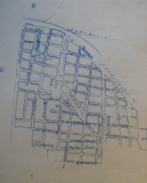
. Box 124.") Sketch of Colonia Morelos. Unknown author. Oscar and Ruth Lewis Papers, 1944–1967. “Peluqueros Census Data” (1956). Box 124.
Sketch of Colonia Morelos. Unknown author. Oscar and Ruth Lewis Papers, 1944–1967. “Peluqueros Census Data” (1956). Box 124.
Footnotes
(1) March 9, 1944. Quoted in Susan M. Rigdon, The Cultural Facade: Art, Science, and Politics in the Work of Oscar Lewis (Urbana: University of Illinois Press, 1988), 198.
(2) Oscar to Ruth Lewis. July 1957. The Cultural Facade, 219.
Please note:
The contents of this blog do not necessarily reflect the views of the Center for Latin American Studies or the University of Chicago.
Oct 20, 2015 |
By Marcella de Araujo Silva I Visiting Brazilian PhD student at CLAS
In 2009, the Brazilian government announced the creation of a new housing program. After a three-decade gap in public policy, Minha Casa Minha Vida (My Home My Life) promised the greatest provision of housing funding for historically marginalized populations. Families whose monthly income was up to R$5000 (around US$1200) could finally apply for different types of grants according to their income brackets. They are three: bracket one comprising families whose incomes vary between R$0 and R$1600; bracket two, R$1601–R$3275; and bracket three, R$3275–R$5000. Bracket one is also known as the “social interest bracket” and subsidies go up to 95% of housing cost.
The social dimension of such a program is better understood if we take into account the depth of the Brazilian housing deficit. According to Fundação João Pinheiro’s national statistics, there is a lack of 7 million housing units nationwide. The numbers are even worse if we consider living standards such as urban infrastructure, house densification, inadequate shelter, inadequate landing, and bathroom-less houses. Ninety percent of the Brazilian housing deficit—either quantitative or qualitative—involves the poorest families whose meager earnings do not exceed R$1600 (approx. US$400) monthly (1).
Despite its undeniable social purpose, Minha Casa Minha Vida was also created with an economic goal. The program was conceived in the aftermath of the 2008 crisis as an anti-cyclical measure. On the one hand, the Brazilian government would finance building contractors, expanding the market and creating thousands of jobs. According to the president of Câmara Brasileira de Construção Civil (Brazilian Chamber of Building Construction), by November 2014, there were 500,000 workers whose jobs were on Minha Casa Minha Vida building sites (2). In addition, the federal government would help millions of poor families’ dreams of owning a house come true, as Banco do Brasil (Bank of Brazil) repeatedly advertised on television. Financing production and granting consumption was for at least four years the class-conciliation strategy of economic growth with social redistribution fostered by the Partido dos Trabalhadores’ (Workers Party). Minha Casa Minha Vida promptly became the second most important social policy in the country, right after Bolsa Família, the government’s poverty eradication program.
 Minha Casa Minha Vida popular condominium in Colônia Juliano Moreira, Jacarepaguá neighborhood, West Zone, Rio de Janeiro. Photo by Samantha Gifalli.
Notwithstanding, since its release, social movements and urban researchers have scrutinized Minha Casa Minha Vida’s apparent success. Even though the program addresses an old social demand, its mode of production, the form and physical quality of the new apartment buildings, and its territorial and social effects are objects of criticism (3).
Among architects and urban planners, Minha Casa Minha Vida’s most criticized aspect is its institutional framework. Enrollment varies according to income bracket. For brackets two and three, the dynamics are exactly the same as any regular real estate market. The negative outcomes are predictable. Since there is more credit, apartment prices increase enormously, sometimes making it nearly impossible for families to afford a new house. Since 2008, skyrocketed rents—97% higher in São Paulo and 144% in Rio—have pushed families from central areas towards more distant ones. For the social interest bracket, the enrollment procedure is two-fold: families might enroll themselves or they might be registered by social workers, according to maps of natural disaster risk areas. The outcomes are highly controversial and conflicting: depending on risk areas’ geographical limits, higher-income families unwilling to leave their houses for tiny apartments are registered, and extremely poor families who have lost shelter and belongings countless times are not.
Bypassing Ministério das Cidades’ (Ministry of Cities) intersectorial perspective of housing, sewage, and urban mobility programs, Minha Casa Minha Vida does not address sustainable urban infrastructure. For instance, in the metropolitan area of Rio de Janeiro alone, between 2010 and 2012, almost 100,000 apartments were built, most of them in areas with limited access to public transportation and bereft of urban and social facilities. Hence architects and urban planners perceive the program as a massive production of housing units, rather than urban planning.
Not only does the project consist of building great numbers of units, but it does so in highly concentrated spaces. In the city of Rio, 27,000 units are distributed among only 82 condominiums. Each of them is shaped as an enclave, with high security bars, controlled entrances, and inner recreational areas of poor quality—a housing type until now more common among upper classes gated communities. Once they are handed over to the new residents, they become private spaces, privately managed. The extra expenses caused by this privatization make the housing scheme unaffordable to social interest bracket families.
Finally, these popular condominiums are distributed across cities according to the income brackets they encompass. In Rio’s most valued areas—the South Zone, nearby downtown, and near North Zone—where urban land prices are higher, barely any Minha Casa Minha Vida housing can be found. However, in the West Zone, unfairly known as the hinterlands of the city, there is great concentration of low-income condominiums. Thus, two modes of segregation overlap: the center-periphery and the gated-community.
As we can see, the current Brazilian housing program is highly controversial and it poses important challenges to sociological inquiry. What roles do these apartments play in poor families’ economic strategies and housing trajectories? How are these popular condominiums inscribed in the urban fabric? What kind of city is under construction? Only good qualitative and ethnographic research can unfold these processes and shed light into how people are coping with their dilemmas.
Footnotes
(1) Fundação João Pinheiro (2012). Déficit habitacional no Brasil 2009 / Fundação João Pinheiro, Centro de Estatística e Informações. – Belo Horizonte.
(2) http://www.brasil.gov.br/economia-e-emprego/2014/11/minha-casa-minha-vid…
(3) All recent publications on Minha Casa Minha Vida and other urban-related themes can be found on this website http://www.habitacaoecidade-observatoriodasmetropoles.net/?cat=6