A Guide to the Digital Companion to "Tiwanaku and Its Hinterland"
Visit Online Tiwanaku
The Online Tiwanaku website is a digital companion to “Tiwanaku and Its Hinterland Vols. 1 & 2,” edited by Alan L. Kolata of the University of Chicago. As a supplement to the print publication it makes available much of the data from the excavation of this site in a digital format for the use of the community of interested scholars and students. While it is not a comprehensive digitization of the published volumes, such data as was available is made accessible here, as is. We invite you simply to explore the site but have included a few tips and details below.
Explore
The Explore feature lets you navigate project data either by Excavation Area or by using a Map view.
Choose the Excavation Area option for an index of the major areas of excavation of Tiwanaku or Lukurmata, or for a list of the survey areas. Clicking on an excavation area from the index opens the door to the excavation units, their levels and features, and their associated small finds, organized hierarchically and with virtually endless click-through potential.
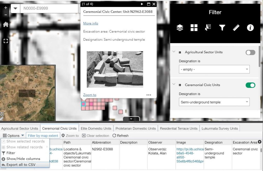
Choose the Map option to use features provided by ArcGIS Online (from Esri) to visualize and investigate the units of excavation from Tiwanaku, Lukurmata, and the Hinterland, spatially situated on a satellite map, topographic map, or excavation plan.
In Map view, experiment with the widgets provided to explore these areas of investigation. Most excavation or survey units represent 2 x 2 meter squares. Toggle raster images on, as provided by the Layer List, to show spatial context. “More info” links provide access to the full details available for each of these units of investigation, live from the OCHRE database. Squares shown in a darker shade represent those that have linked photographs available for viewing.
Explore the options available on the Map layers’ “…” menu to Zoom to, Toggle on/off, or adjust the transparency of selected layers.
Use the Search box at the top left of the Map to find a particular Unit that corresponds to an item described in the print publication.
Pull up the Attribute tables of related data for the shape layers using the arrow at the bottom of the view. Download these tables to CSV format files, or filter/customize them at will.
A Note on the Coordinate System and N-E Notation
The N-E notation used at these sites is based on arbitrary grids set up for the purpose of recording excavation data. For this presentation, and to support the usability of these data in modern GIS systems, these N-E coordinates have been mapped to coordinates in the UTM 19S projected coordinate system. The Northing and Easting data used to identify the units of excavation—e.g., the center point of the Lukurmata grid, N3000-E3000—will not correlate directly to the Northing and Easting coordinates of the UTM 19S coordinate space. The units of excavation will, however, fall approximately at the correct location in geographic space as shown on the basemaps provided. Modern standards of precision are not to be imposed on this data which was not collected to such rigorous standards in the late 1980’s and early 1990’s. The current projections are, rather, intended to provide helpful visual context for the units of excavation without holding them to exact standards that might be expected today.
Tables
The Tables pull data dynamically from the OCHRE database and are organized by type of artifact or collected material. Use the filter field to search for items that match on any term provided. Here, for example, we find Corn samples among the Botanical remains.
Click on the Name of an item to see its full published details. Each item will link to all of its related items: ancestor items, in context; child items, in context; images and other linked items. The click-through potential is almost unlimited.
Photographs
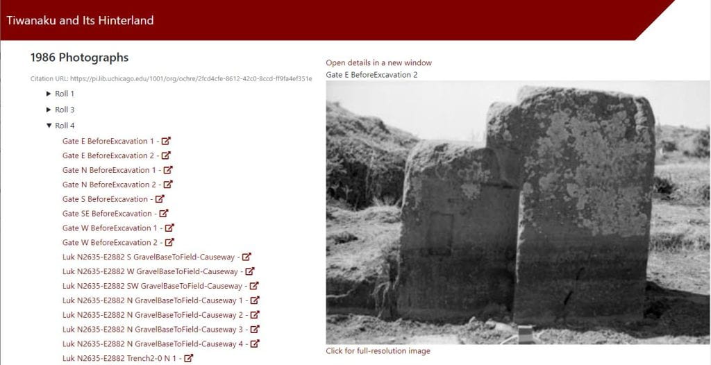
The Photographs provide an extraordinary view into the excavations at Tiwanaku and its vicinity. Many of the photographs will be linked to other published items, and are therefore accessible in other ways, but this option provides galleries of photos by year and by film roll number. Browse these and watch Tiwanaku come to life!
Click the image to view a high resolution version. The image properties and full details are available on click-through to a new window using the link provided.
NOTE: if photographs are not loading as shown below (or in a map interface), then you may need to configure your web browser to allow pop-ups from http://pi.lib.uchicago.edu and from http://ochre.lib.uchicago.edu.

Sample photograph list from Tiwanaku website
PDFs
The PDFs provide access to scans of the primary hand-written record of the excavation. They are organized, generally, by year, by excavator, and by site. Some of the forms are clustered into sub-groups which reflect, in part, the original organization of the forms in the physical binders or file folders that contain the paperwork. In this case the sub-group heading indicates the Northing number of the Unit represented by the initial form in the group, but will likely also contain forms for other Units in the vicinity.
View, print or save documents of interest.
Acknowledgements
Project data is managed by the OCHRE platform and supported by the OCHRE Data Service at the University of Chicago.
Special thanks to research assistant Rowan Choe-Maher for their considerable help with collecting, cleaning, and converting the project data, and to GIS specialist Eric Hubbard for his assistance.


