
Comuni, Architecture, and Technology Align in Space and Time Online (CATASTO)
Niall Atkinson Associate Professor of Art History, Romance Languages and Literature, and the College, University of Chicago
In 1427, the Florentine government conducted an extensive and detailed account of the financial state of its citizens in what would be the first comprehensive modern tax assessment in Europe. Known as the Catasto, this archive represents the property holdings and net worth of every household in the city’s jurisdiction. The massive amount of data continued within the Catasto’s registers has provided the basis for a wide range of scholarly investigations. In the late 19th century it was used to excavate, document, and map the landholding patterns of the city’s central region by Guido Carocci during the massive demolitions carried out in the name of slum clearance. It also provided the basis for the comprehensive sociological study carried out by the historian David Herlihy in the 1970s, which culminated in the publication of the monumental volume Les Toscans et leurs familles: une étude du “catasto” florentin de 1427. Using punch cards and statical analysis, this project expressed the historical potential of large scale quantitative methods brought to bear on a pre-modern society using the most cutting-edge computational technologies available at the time.
It is in this archaeological, social, and topographical spirit that “CATASTO” (Communities, Architecture, and Technology Align in Space and Time Online) was conceived as a digital mapping project to transform the real-estate information embedded in these Florentine tax returns into a visual representation of the city’s social demography. Yet without any fixed system of addresses in the modern sense, Florentines located themselves and their properties using a relational system of neighbors. In other words, where they were defined who they were within a complex social network of family members, business associates, friends, and neighbors in relation to architectural infrastructure of the city. This relational system complicates the creation of a full socio-geographic profile of the city. The CATASTO Project uses digital methods to interpret the 1427 Catasto and transform its non-standard, semi-structured social and spatial data into a machine-readable state. Led by Professor Niall Atkinson (Art History), in collaboration with Carmen Caswell (Forum for Digital Culture), the CATASTO Project uses the Online Cultural and Historical Research Environment (OCHRE) to catalog and manage the many facets of this unique, complex dataset as it works to model these relative relationships in physical space. The goal is to construct a data-rich digital topography of the remarkable urban society of Renaissance Florence precisely at the historical moment in which it was producing some of the most important artistic and architectural monuments of the western canon.
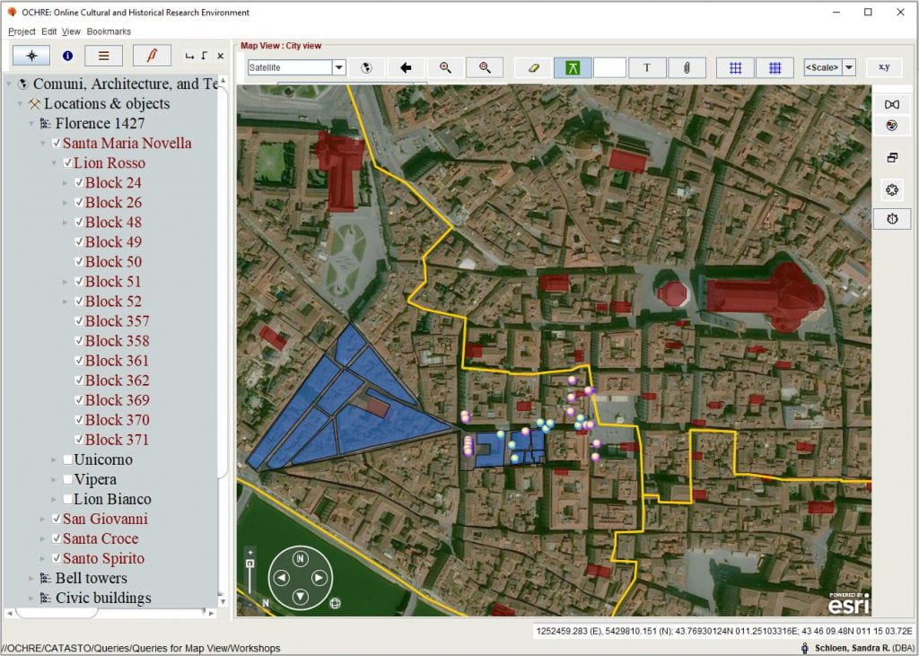
A cluster of workshops listed in the 1427 Catasto, plotted in the Lion Rosso district of Florence.
The Catasto of 1427 is a rich, deep vein of demographic and spatial information in the form of quasi-structured, non-standardized text. OCHRE’s flexibility allows us to organize and query this text as we interpret the social relationships and geographic layout of the pre-modern city. The integration of GIS, network visualization, and web publishing tools streamline the workflow as the loose text is transformed into machine-readable, openly-accessible data.